If you’re shopping waterfront on Wadmalaw Island, you’ll see the word “deepwater” everywhere. It sounds simple, but it is not a one-size-fits-all promise. Your boat, the tides, and the exact location all change what “deepwater” means for you.
In this guide, you’ll learn how the term is used in Charleston-area listings, how local tides and channels affect real access, and the public resources you can use to verify a property before you buy. You’ll also get a practical checklist to make due diligence smoother. Let’s dive in.
What “deepwater” means in listings
“Deepwater” is a marketing term, not a legal standard. In the Charleston market, it usually signals water access that can accommodate powered boats without regular grounding at typical tides. The exact depth is not guaranteed and varies by location and vessel.
Here are common variations you’ll see and what they imply:
- Deepwater, direct access: Frontage on a marked channel or river with no fixed low bridges blocking access to Charleston Harbor or the Intracoastal Waterway.
- Protected deepwater or deepwater creek: A deeper channel near the dock in a sheltered tidal creek, often calmer than open water.
- Private deepwater dock: A dock the seller says fits larger boats. You still need to verify dock permits, condition, and depth at low tide.
- Dredged deepwater: Depth created or maintained by dredging. Confirm who pays for maintenance and how often it occurs.
Buyer takeaway: treat “deepwater” as a starting point. Verify the actual depth at your dock and along your route at low tide.
Tides, depths, and your boat
The Charleston coast has semidiurnal tides, with two highs and two lows each lunar day. Water level can swing several feet between mean low water and mean high water. A depth measured at high tide can be much less at low tide.
- Always ask for depths relative to a tidal datum, preferably mean low water (MLW).
- Use Charleston tide predictions to understand seasonal and lunar variations.
- Study NOAA nautical charts for charted soundings and marked channels near the property.
Practical depth guidance by vessel type varies, but here are helpful rules of thumb:
- Kayaks and small skiffs: 1–2 feet can be workable in creeks at low tide.
- Typical center consoles and recreational powerboats: Many owners target 3–4 feet under the hull at low tide, with extra margin for propellers.
- Keel sailboats and larger yachts: Often require 4–6+ feet for smaller keelboats and 6–10+ feet or more for larger vessels, plus access to maintained channels.
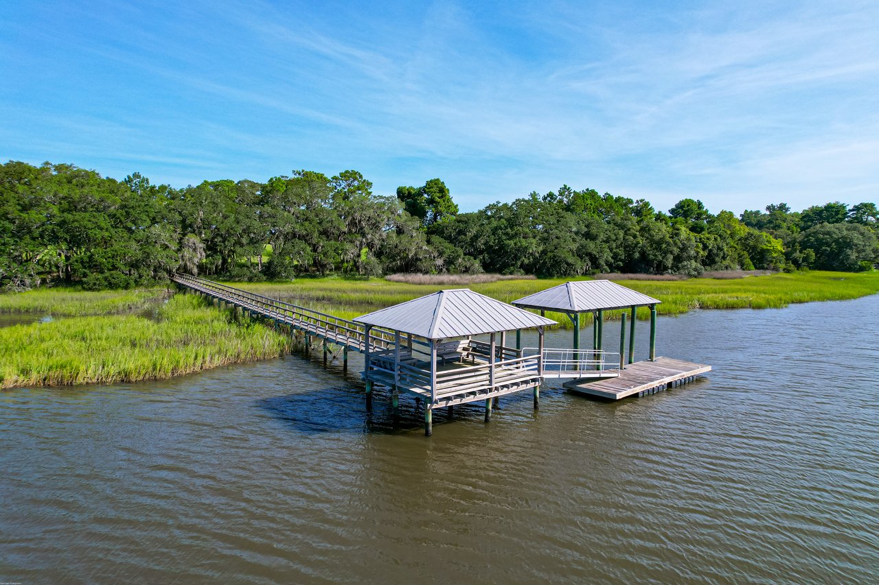
Wadmalaw’s waterways and routes
Wadmalaw Island is edged by tidal marshes and winding creeks, with deeper water concentrated in main channels like the Stono River. Many marsh-front lots are shallow near the bank and only reach better depth in the channel’s centerline.
- Properties on narrow creeks may be tide-dependent. Some routes are navigable for skiffs but not for deeper-draft boats at low water.
- Access to bigger water depends on your route to a main channel and whether you face any low fixed bridges. Check bridge heights and updates in the U.S. Coast Guard Local Notice to Mariners.
- Shoaling and shifting sandbars are common in tidal creeks. Conditions change over months and years, especially after storms.
Who maintains the channel
Not every channel is federally maintained. Federal channels are dredged periodically and tend to hold deeper, more reliable depths. Many neighborhood or private channels rely on local agreements for maintenance.
- Review USACE Charleston District navigation updates to see which channels are maintained and when they’re dredged.
- If depth depends on dredging, verify any recorded agreements, cost-sharing, and schedules before you buy.
Docks, permits, and local records
Dock construction and shoreline work typically require state permits, and some older structures may be nonconforming. Confirm that the dock you see is the dock that was permitted.
- Search permit history through SC DHEC OCRM coastal permitting to verify dock and shoreline approvals.
- Use Charleston County GIS to view parcel boundaries, shoreline features, and possible easements.
- Check FEMA Flood Map Service Center for flood zones and base flood elevations that may affect dock heights and access.
Your deepwater due diligence checklist
Use these steps to confirm whether a property meets your boating needs:
- Ask the seller or listing agent for documented depth at the dock stated relative to MLW, plus any recent hydrographic or sonar surveys.
- Review NOAA nautical charts for nearby soundings and the closest marked or federal channel.
- Check USACE Charleston District navigation updates to confirm if your route uses a maintained channel and when it was last dredged.
- Verify dock, pier, and shoreline permits via SC DHEC OCRM coastal permitting and review any county conditions or approvals.
- Order a site-specific hydrographic survey, ideally at or near low tide, especially if boat access is central to your purchase.
- Confirm bridge vertical clearances along your route and review recent changes in the U.S. Coast Guard Local Notice to Mariners.
- Review FEMA flood maps and any elevation certificates for the home and dock.
- Ask if there are recorded agreements or HOA provisions for channel maintenance, dredging assessments, or shared pier expenses.
- Consult a local captain or marine surveyor about practical navigability for your specific vessel and tides.
- Consider insurance needs, including hull and flood policies, and any liability for docks and piers.
Common Wadmalaw scenarios
- You plan to keep a 24-foot center console. A protected deepwater creek with 3–4 feet at MLW near the dock and a short hop to the Stono River might suit you. Confirm actual MLW depth and route clearances.
- You prefer a shallow-draft skiff and kayaking. A marsh-front lot on a tidal creek may be perfect, even if it is not “deepwater.” Check that low-tide water covers your launching area and watch for oyster beds.
- You have a keel sailboat. Being on or very close to a maintained channel is often essential. Verify MLW depths and any fixed bridge heights along your path to open water.
Public access and local knowledge
Even if you plan to keep a boat at your dock, nearby public ramps are useful for test runs and surveys. Find locations through SCDNR public boat access. Pair that with Charleston tide predictions to time visits at low water and see real conditions.
Local marinas, harbormasters, and commercial captains are invaluable for real-time shoaling and seasonal tips. Combine that on-the-water insight with charts, permits, and surveys for a complete picture.
Ready to evaluate a Wadmalaw waterfront?
Buying “deepwater” on Wadmalaw is about matching your boat and lifestyle to a specific shoreline, dock, and route. With the right verification, you can enjoy reliable access and protect your long-term value.
If you’re considering a waterfront move, let a lifelong Charlestonian guide your search. Reach out to Stephanie Wilson-Hartzog for thoughtful, high-touch representation and a clear plan for due diligence.
FAQs
What does “deepwater” mean in Charleston real estate?
- It is a marketing term that suggests boat-friendly access, but there is no official depth; you should verify actual MLW depths, permits, and route conditions.
How many feet is “deepwater” on Wadmalaw Island?
- There is no single number; depth needs depend on your vessel’s draft and route, so confirm MLW depths at the dock and along the approach channel.
How do tides affect dock access around Wadmalaw?
- Charleston has semidiurnal tides with significant range; a depth measured at high tide can shrink substantially at low tide, so use MLW as your baseline.
Who maintains channels near Wadmalaw if shoaling occurs?
- The U.S. Army Corps of Engineers maintains designated federal channels, while neighborhood or private channels typically rely on local agreements and owner assessments.
How can I verify a dock permit in South Carolina?
- Check the SC DHEC Office of Ocean and Coastal Resource Management permit records and confirm that existing structures match approved plans.
What are the biggest risks to deepwater access?
- Shoaling, unpermitted or deteriorated docks, low bridge clearances, and changes in channel maintenance can limit navigation and increase costs.